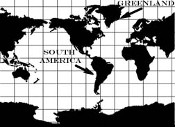
Globe Projection:Description: Globe projections are a spherical model of the earth. Advantages:
Disadvantages:

Cylindrical ProjectionDescription: Cylindrical projections are designed as if a cylinder were wrapped around the globe; both the longitude and latitude lines are straight and parallel. Advantages:
Disadvantages:

Pseudocylindrical ProjectionsDescription: Pseudocylindrical projections have latitude lines that are straight and parallel, and longitude lines that are equally spaced. However on a pseudocylindrical projection only the central longitude line, or the Prime Meridian, is straight; all the other longitudinal meridians are curved. Advantages:
Disadvantages:

Conic ProjectionDescription: Conic projections are designed as if a cone were placed over the globe. Advantages:
Disadvantage:

Flat plane projectionDescription: If a flat projection were placed on a globe it would only touch the globe at one point. Flat plane projections can be placed anywhere on the globe, though the projection will always be calculated from the center point. Advantages:
Disadvantages:

Equal-Area ProjectionsDescription: Equal-area projections that accurately depict area on all regions of the map at one time. Equal-area projections that portray the entire earth look as if someone has cut a globe and then attempted to smooth it out on a flat surface, which distorts the shape. Advantages:
Disadvantage:
|
About Us | Terms of Use | Contact Us | Partner with Us | Press Release | Sitemap | Disclaimer | Privacy Policy
©1999-2011 OpenLearningWorld . com - All Rights Reserved